Summer Weather With Beach Hazards & High Surf
Heat returns to our area over the next few days...but before you head to the beach, beware of high surf and sneaker waves!
A strong ridge of high pressure will move into Northern California on Wednesday. Its air mass will be unseasonably warm and its position just to our north will lead to compressional warming over our area along with easterly offshore flow—which is typically warm and dry as well! Highs are expected to be anywhere from 10 to 20ºF above normal. King City’s record high of 96ºF on Wednesday is the most likely to be tied or broken—Salinas’ 100ºF record is likely out of reach. The ridge will begin to move to our east on Thursday, though the warm air mass will remain intact. The door will be left open for southerly flow at the surface, however, so a southerly surge could cool us off on the coast before reaching the currently forecast Thursday highs. All areas will cool significantly into the weekend—see “extended” for more.
AIR QUALITY: Good
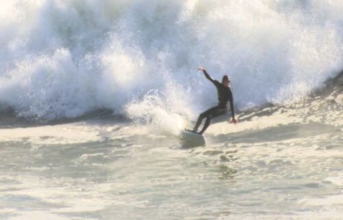
*Beach Hazards*
… for the immediate coast of Santa Cruz & Monterey Counties in effect from NOW until 7AM Thursday when it will be replaced with a HIGH SURF ADVISORY
*Increased threat of sneaker waves expected.
*Greatest risk for west and northwest facing beaches of coastal Southern Monterey Bay, and Big Sur coast.
* Large, unexpected waves can sweep across the beach without warning, sweeping people into the sea from rocks, jetties, and beaches. These sneaker waves can also move large objects such as logs, crushing anyone caught underneath.
Don't be fooled by an ocean that looks calm. There can be 30 minutes of small waves before a sneaker wave strikes. Avoid rocks and jetties. Avoid steep beaches. Stay much farther back from the water and never turn your back on the ocean.
**HEAT ADVISORY**
…for the mountains and higher elevation valleys of Monterey & San Benito Counties and also including the southern Salinas Valley in effect from NOW until 11PM Thursday.
*Daytime temperatures in the 90s to near 100 degrees expected. Overnight lows in the mid 60s in the lower elevations and lower 70s in the hills.
…and for the Santa Cruz Mountains and the KION coverage area in Santa Clara County in effect from 11AM Wednesday until 11PM Thursday.
*Daytime temperatures in the 90s to near 100 degrees expected. Overnight lows in the mid 60s in the lower elevations and lower 70s in the hills.
*Hot temperatures may cause heat illnesses to occur.
*In addition to the heat, individuals should be mindful of the elevated fire danger, especially at higher elevations where there will be minimal overnight relief.
Drink plenty of fluids, stay in an air-conditioned room, stay out of the sun, and check up on relatives and neighbors. Young children and pets should never be left unattended in vehicles
under any circumstances.
Take extra precautions if you work or spend time outside. When possible reschedule strenuous activities to early morning or evening. Know the signs and symptoms of heat exhaustion and heat
stroke. Wear lightweight and loose fitting clothing when possible. To reduce risk during outdoor work, the Occupational Safety and Health Administration recommends scheduling frequent rest breaks in shaded or air conditioned environments. Anyone overcome by heat should be moved to a cool and shaded location. Heat stroke is an emergency! Call 9 1 1.
Wednesday: Expect wall to wall sunshine. Light offshore breezes early in the day will allow for significant heating all the way to the coast. Then, a weak sea breeze will regulate coastal temperatures late in the day. Expect coastal highs in the mid-70s to around 90ºF and inland highs ranging from upper 80s to mid 90s.
Overnight: Mostly clear, with lows in the 50s for most locations. Hills and mountains will be warmer in the mid to upper 60s. A few patchy low clouds could develop around the immediate coast by sunrise, producing areas of patchy fog.
Thursday: Mostly sunny and very warm to hot. Expect coastal highs in the 70s to low 90s with widespread 90s inland. Cooler, breezier conditions on the coast late with the potential for some low cloudcover.
**HIGH SURF ADVISORY**
… for the immediate coast of Santa Cruz & Monterey Counties in effect from 7AM Thursday until 7PM Thursday
*Large breaking waves of 17 to 22 feet with focal points pushing 30 feet.
*Dangerous swimming and surfing conditions and localized beach erosion. Large, unexpected waves can sweep across the beach without warning, sweeping people into the sea from rocks, jetties, and beaches. These sneaker waves can also move large objects such as logs, crushing anyone caught underneath. Large turbulent surf may be difficult to escape or achieve rescue.
Inexperienced swimmers should remain out of the water due to dangerous surf conditions.
A High Surf Advisory means that high surf will affect beaches in the advisory area, producing rip currents, localized beach erosion, and sneaker waves.
Remain out of the water to avoid hazardous swimming conditions.
Extended: Temperatures drop into the weekend as a trough approaches from the west. Highs will actually be below normal by Saturday for all areas. A weak cold front may reach our shores on Sunday with some drizzle to light rain.
-------------------------------------------------------------------------
This week's normal temperatures:
--COASTAL CITIES--
LOW: 51ºF
HIGH: 70ºF
--INLAND CITIES--
LOW: 47ºF
HIGH: 79ºF
--------------------------------------------------------------------------
-The outlook from the Climate Prediction Center for October 25th – 31st calls for the likelihood of BELOW normal temperatures and near normal precipitation.
- ENSO (El Niño/La Niña) STATUS: El Niño Advisory
- ENSO Forecast: Strong to Very Strong El Niño expected this winter.
-Area drought status: Currently drought-free