The West’s historic drought in 3 maps
The West experienced extremely low rain and snowfall over the past year
By John Keefe, Rachel Ramirez and Angela Fritz, CNN
After months of extreme drought, the wet season has arrived in the West. Though rain is much needed, extreme downpours could unleash flash floods and treacherous debris flows.
The season could alleviate the drought and fire conditions, but the long-term impacts of drought persist.
In California, drought conditions this summer were the most extreme in the entire 120-year record. Gov. Gavin Newsom issued a statewide drought emergency proclamation. Firefighters have seen more than 8,000 fires this year, which torched nearly 2,500,000 acres so far, according to data from Cal Fire.
“As the western US faces a potential third year of drought, it’s critical that Californians across the state redouble our efforts to save water in every way possible,” the governor said in a statement.
While the rains may alleviate fire conditions, experts say La Niña conditions could exacerbate the drought, particularly in the Southwest.
Scientists say the West’s historic, multi-year drought is a clear sign of how the climate crisis is affecting not only the weather, but water supply, food production and electricity generation.
Drought map
More than 91 percent of the West is in drought this week, according to the US Drought Monitor, with five states entirely in drought conditions: California, Nevada, Idaho, Utah, and Montana.
The drought has also expanded from the West into the the coastal regions of the East. Still, California drought remains significant and there has been little change in the past few weeks, with nearly half of the state in exceptional drought, the Drought Monitor’s most severe category.
Though the wet season is kicking off in California this week, the intense drought could increase the risk of flash flooding and mudslides. Rain storms could generate too much rain, and too fast, and could cause dangerous conditions.
The drought is also straining water resources. The US Bureau of Reclamation said in September that there’s a 3% chance Lake Powell, a major reservoir on the Colorado River, could drop below the minimum level needed to allow the lake’s Glen Canyon Dam to generate hydroelectricity next year. In 2023, the chance of a shutdown grows to 34%, according to the bureau’s projection.
There is also a 66% chance that Lake Mead could drop below the critical threshold of 1,025 feet above sea level in 2025, the bureau said. If water levels stay below that critical threshold, it would trigger deep water cuts, potentially affecting millions of people in California, Arizona, Nevada and Mexico.
The bureau in August declared a water shortage on the Colorado River for the first time, triggering mandatory water consumption cuts for states in the Southwest beginning in 2022.
As the planet warms, drought and extreme heat will also fuel deadly wildfires. Multiple studies have linked rising carbon dioxide emissions and high temperatures to increased acreage of burning across the West, particularly in California.
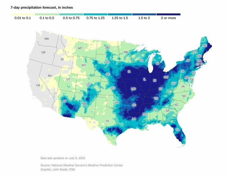
Rainfall outlook
The West experienced extremely low rain and snowfall over the past year, compounded by drastically high temperatures. Less rain and increasing heat waves have led directly to drought conditions and water shortages.
“The increase in precipitation, related to the onset of the wet season, along with much cooler temperatures resulted in a large decrease in the number of large wildfires throughout the West during mid-October,” according to the US Drought Monitor.
But even as the Monsoon season ends and the wet season begins, the drought monitor notes that long-term drought impacts will continue to persist.
As climate change accelerates and winter temperatures increase, snowfall will decrease. High-elevation snowpack serves as a natural reservoir that eases drought, storing water through the winter months and slowly releasing it through the spring melting season.
Stream and river flow
Streamflow, a measure of how much water is carried by rivers and streams, is another significant indicator of drought and its impact.
As drought conditions have worsened in 2021, hundreds of stream and river locations are experiencing below-average flow. Fishing restrictions have also been put in place on many rivers in Montana due to low flows and warm waters.
But as the wet season begins, streamflows in the West are improving, according to the Drought Monitor.
Changes in streamflow affect the water supply for municipal use such as drinking and bathing, crop irrigation and power generation.
The-CNN-Wire
™ & © 2021 Cable News Network, Inc., a WarnerMedia Company. All rights reserved.