Chilly Monday Morning, Nice Afternoon Ahead
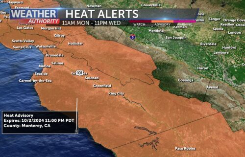
Quiet weather will continue as we start the work week. Our pattern is blocked to some extent with a ridge to our north and an upper level low nearby. The low is why we’ve had a few high clouds around the region. The ridge begins to move to the east Monday which will kick the low back west, destined to be absorbed into the incoming storm system. Monday afternoon’s temperatures will likely be the warmest of the next week, so if you need to do anything outdoors, now’s the time! Clouds will increase on Tuesday as the next system approaches. It will be here overnight into Wednesday morning bringing mainly light to briefly moderate rains to the Monterey Bay Region. Trailing disturbance(s) will keep rain chances in the forecast through Friday.
AIR QUALITY: Good
Monday: Scattered high clouds early, thinning in the afternoon. Slightly warmer with highs in the 60s to around 70ºF. Breezy offshore winds early, then onshore in the afternoon. Also, occasionally breezy in the hills with southerly winds.
Overnight: Scattered high clouds passing through will make for partly cloudy skies. Expect another chilly night with lows mostly in the 40s near the coast, 30s and 40s inland with valleys dropping into the upper 20s.
***FREEZE WARNING***
From the National Weather Service in effect from 10PM Monday through 9AM Tuesday for the higher and southern valleys of San Benito and Monterey Counties
*Sub-freezing temperatures as low as 28 expected.
*Frost and freeze conditions will kill crops, other sensitive vegetation and possibly damage unprotected outdoor plumbing.
Take steps now to protect tender plants from the cold. To prevent freezing and possible bursting of outdoor water pipes they should be wrapped, drained, or allowed to drip slowly. Those that have in-ground sprinkler systems should drain them and cover above-ground pipes to protect them from freezing.
Tuesday: Mostly sunny to start with Increasing clouds (both low & high) after lunch. Cooler, with highs in the 60s. Breezy south-southwesterly winds at times. Precipitation possible by midnight in the coastal mountains, mainly in the north.
Extended: We’re likely to see a few rounds of showers Wednesday through Friday—most likely the farther north and west you are. Rain shadowing could make accumulating rainfall more difficult in valleys of Monterey/San Benito Counties. Dry conditions return this weekend, though northwesterly flow will keep temperatures seasonably cool.
-------------------------------------------------------------------------
This week's normal temperatures:
--COASTAL CITIES--
LOW: 43ºF
HIGH: 61ºF
--INLAND CITIES--
LOW: 38ºF
HIGH: 63ºF
--------------------------------------------------------------------------
-The outlook from the Climate Prediction Center for December 4th – 10th calls for the likelihood of ABOVE normal temperatures and near normal precipitation.
- ENSO (El Niño/La Niña) STATUS: El Niño Advisory
- ENSO Forecast: Strong to Very Strong El Niño expected this winter.
-Area drought status: Currently drought-free