Sunday Evening Showers
The air mass warms slightly on Sunday, so most areas will be a touch warmer. However, clouds will be on the increase—especially in the north—so some locations across Santa Cruz County may actually cooler. Why will clouds be on the increase? Well, I’m glad you asked! A frontal system will “take aim” on our area Sunday night with a weak warm front bringing a chance for a few light showers from the late afternoon into the early evening and then the corresponding cold front bringing another similarly slight chance of showers late in the evening. Precip with this frontal system will be light and may not reach some inland areas. Behind the front, gusty northwest winds will pick up into Monday.
AIR QUALITY: Good
Sunday: Mostly clear and cool early with clouds increasing in the afternoon. A chance of rain from mid-afternoon into the evening around the bay and a chance for isolated showers farther inland. Highs in the upper 50s to mid-60s. Breezy up valleys late in the day, then winds picking up out of the northwest into late evening for all areas.
Overnight: A few light showers possible early, then slow clearing. Breezy at times. Cool with lows in the 30s-40s.
Monday: Mostly sunny with gusty northwesterly winds at times. Dry and cool with highs in the 50s to low 60s.
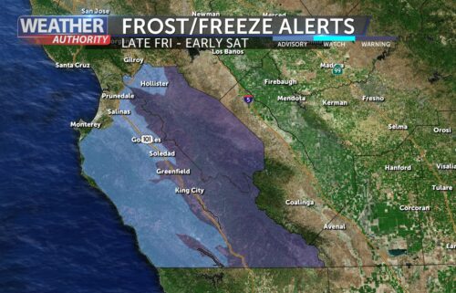
*FREEZE WATCH*
…for the mountains and inland valleys of Monterey and San Benito Counties in effect from late Monday night through Tuesday morning.
*Sub-freezing temperatures as low as 26 possible.
*Frost and freeze conditions could kill crops, other sensitive vegetation and possibly damage unprotected outdoor plumbing. Cold conditions will be hazardous to sensitive populations such as unhoused individuals. Cold Conditions can lead to hypothermia with prolonged exposure.
Take steps now to protect tender plants from the cold.
Extended: Winds will ease on Tuesday but we’ll remain in cool northwesterly flow. High pressure slowly builds in through the end of the week all while a plume of moisture is directed to the coast to our north. We’ll slowly warm through around Thursday or Friday with highs returning to or possibly slightly exceeding normal. Then, once the ridge flattens, some rain may sneak through—somewhere in the Friday to Sunday time frame. Stay tuned!
*Note: Any alerts from the National Weather Service in Monterey will be noted in italics above. Alerts may be edited for brevity or local clarification
-----------------------------------------------------------------------
This week's normal temperatures:
--COASTAL CITIES--
LOW: 46ºF
HIGH: 66ºF
--INLAND CITIES--
LOW: 41ºF
HIGH: 69ºF
--------------------------------------------------------------------------
-The outlook from the Climate Prediction Center for November 24th – 30th calls for the likelihood of BELOW normal temperatures and ABOVE normal precipitation.
- ENSO (El Niño/La Niña) STATUS: La Niña Watch
- ENSO Forecast: Transition to La Niña into the fall and persist through the winter months.
- Area drought status: Abnormally dry for areas around Monterey Bay northward. Drought-free elsewhere.
- Monterey Bay Sea Surface Temperature as of November 17th : 54.5ºF (avg of 7 buoys) [November Average: 56.6ºF]


