Changes Brewing
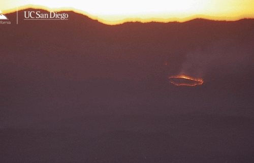
Another quiet day with tranquil weather as a weak weather system approaches from the northwest. It’ll pass by on Wednesday with a few sprinkles for the area, but that’s about it. Another system will then move down into the Great Basin from the north Thursday into Friday. It will bring a cool, dry air mass into the region and its approach will kick up strong northerly winds. Initially moist, the air will dry significantly into Friday and Saturday, increasing fire danger. A Fire Weather Watch is now upgraded to a Red Flag Warning beginning late Thursday evening for most of the Central Coast as fuels continue to dry with low humidity and the increasing winds, gusting up to 40-50 mph and higher in isolated areas.
AIR QUALITY: Good
*Beach Hazards*
…for the immediate coast of Monterey and Santa Cruz Counties through Wednesday evening.
*A moderate period northwest swell will result in a more energetic surf zone. Breaking waves of 6 to 8 feet are expected.
*Large waves can sweep across the beach without warning, pulling people into the sea from rocks, jetties, and beaches.
Inexperienced swimmers should stay out of the water. Observe the ocean for 20 minutes before relaxing near the water. Know where your lifeguards are, obey their instructions, and never turn your back on the ocean!
Today: Mostly cloudy early, then becoming partly to mostly sunny. Expect costal highs in the low 60s to mid 70s—warmest on the north side of the bay—and mid 70s to mid 80s inland. Breezy westerly onshore flow becoming windy up valleys late in the day.
Overnight: Mostly cloudy at the coast with increasing clouds inland with patchy fog/drizzle. Lows in upper 40s to 50s.
Wednesday: Partly cloudy with a chance for a few sprinkles. Otherwise, slightly cool with highs in the 60s-70s for most areas. Low clouds thicken late with drizzle possible. Breezy northwesterly onshore flow becoming windy up valley slate in the day.
Extended: Thursday morning will start out on a damp note with drizzle possible and northwesterly flow will strengthen during the day. Flow will slowly move more to the north into Friday and the air will dry out. Temperatures will be cool for this time of year Thursday, then highs will warm into the weekend while lows drop! Gusty winds and dry conditions will increase fire danger. Frost may be possible in higher valleys by Saturday and Sunday mornings!
***RED FLAG WARNING***
RED FLAG WARNING NOW IN EFFECT THURSDAY NIGHT THROUGH SATURDAY EVENING FOR THE BAY AREA AND CENTRAL COAST AS STRONG OFFSHORE WINDS AND CRITICALLY DRY CONDITIONS ARE EXPECTED TO DEVELOP... .
...Gusty north-northeast winds are expected to develop as an "inside slider" system moves into the Great Basin this weekend. Humidities will still be on the higher end at the start of the event on Thursday, but are expected to quickly dry out as low as 10% Friday and Saturday. Peak winds are expected overnight Thursday night into Friday morning for the North Bay and Bay Area. Most areas across the region will be affected to some degree, with likely exceptions being the immediate Big Sur coast, Monterey Bay coast, and the Marin/Sonoma coast. Winds largely on the order of 25-35 mph can be expected with gusts to 45 mph...isolated gusts to 65 mph across the highest terrain and ridgetops, most notably the North Bay Interior Mountains and the Diablo Range.
* TIMING...11 PM Thursday until 5 PM Saturday
* WINDS...North and northeast 20 to 30 mph with gusts up to 45
mph. Potential for gusts up to 65 mph along ridgetops and the
highest terrain.
* RELATIVE HUMIDITY...As low as 10 percent.
* LIGHTNING...None.
* IMPACTS...The combination of gusty winds and low humidity can
cause fire to rapidly grow in size and intensity. Outdoor
burning is not recommended. Despite recent cool weather and high
humidity, we are expecting a widespread and prolonged offshore
wind event which will likely dry fuels out very quickly given
their volatility over the past several weeks.
PRECAUTIONARY/PREPAREDNESS ACTIONS...
A Red Flag Warning means that critical fire weather conditions
are either occurring now...or will shortly. A combination of
strong winds...low relative humidity...and warm temperatures can
contribute to extreme fire behavior.
This week's normal temperatures:
--COASTAL CITIES--
LOW: 51ºF
HIGH: 71ºF
--INLAND CITIES--
LOW: 46ºF
HIGH: 78ºF
--------------------------------------------------------------------------
-The outlook from the Climate Prediction Center for October 22nd – 28th calls for the likelihood of BELOW normal temperatures and ABOVE normal precipitation.
- ENSO (El Niño/La Niña) STATUS: La Niña Watch
- ENSO Forecast: Transition to La Niña into the fall and persist through the winter months.
- Area drought status: Abnormally dry for areas around Monterey Bay northward. Drought-free elsewhere.
- Monterey Bay Sea Surface Temperature as of October 15th : 58.5ºF (avg of 7 buoys)