Severe storms threaten millions on Memorial Day following a weekend of destructive, deadly weather
Originally Published: 27 MAY 24 00:04 ET
Updated: 27 MAY 24 11:24 ET
By Ashley Williams, Elisa Raffa and Mary Gilbert, CNN
(CNN) — The threat of severe weather expands to millions in the East on Memorial Day after intense and deadly storms ravaged a large area of the central United States over the weekend.
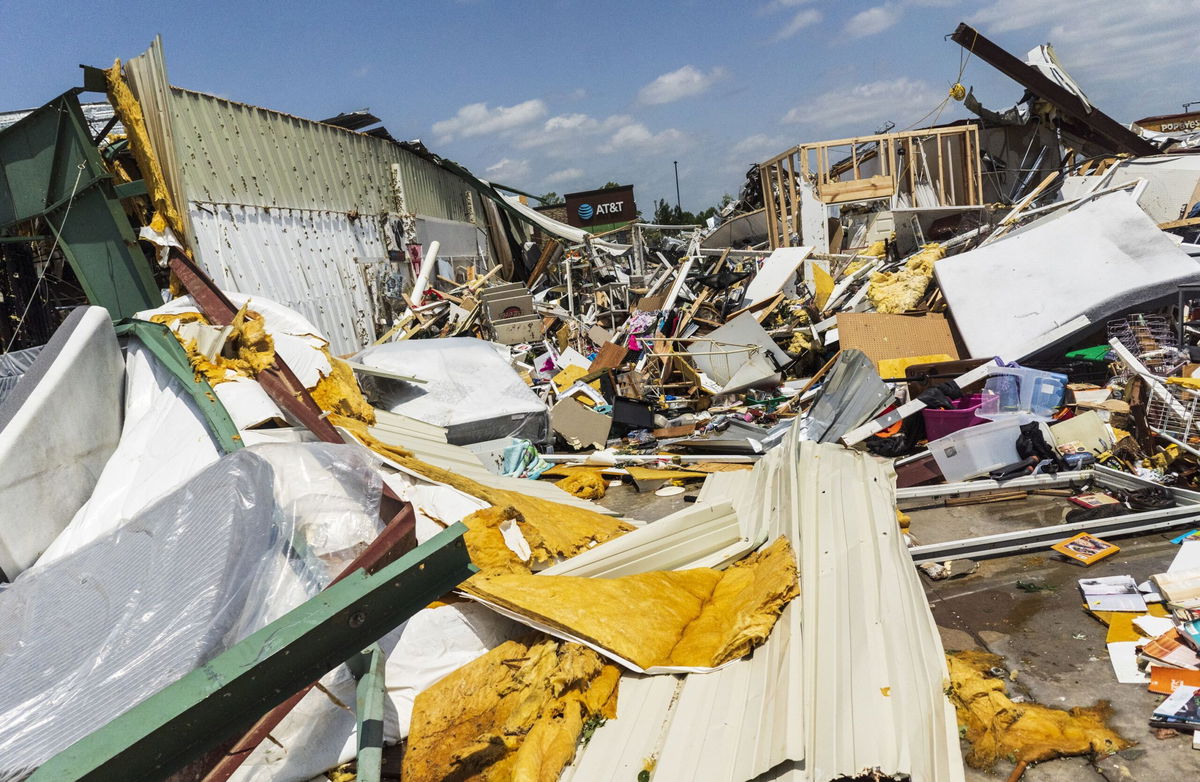
Destructive thunderstorms and tornadoes were responsible for at least 21 deaths over the weekend, including four children, in parts of Kentucky, Arkansas, Texas and Oklahoma. The storms killed 15 in Arkansas and Texas alone. Another four people died in Kentucky.
LIVE UPDATES: At least 21 killed in tornado-spawning storms sweeping central US
Sunday was the busiest severe weather day of the year so far, with more than 600 reports of storm damage across at least 20 states, including tornadoes, wind gusts in excess of 75 mph and hail the size of softballs. Storms turned buildings into piles of rubble, damaged cars and brought down power lines.
More than 600,000 homes and businesses in the central, southern and eastern US were without power in the wake of weekend storms Monday morning, according to PowerOutage.us.
Harsh storms pummeled parts of Kentucky Sunday night and inflicted damage on some communities, prompting Gov. Andy Beshear to issue a state of emergency early Monday. Phone lines in the Bowling Green area were knocked out, leading police to set up alternate emergency numbers for those who needed help.
The National Weather Service office in Paducah, Kentucky, is sending out at least two storm survey teams Monday to assess damage, the office said.
Four storm-related deaths have been reported in the state – one in Hardin County, one in Hopkins County, one in Mercer County and one about 70 miles away in Louisville. Another person is “fighting for their life,” Gov. Beshear said in a Monday news conference.
Severe thunderstorm threat shifts to East
More than 70 million people from the South to the Northeast are under a level 2 of 5 risk of severe thunderstorms Monday.
Powerful storms were ongoing Monday morning in parts of the Southeast, including the Atlanta metro. These storms will slowly taper off in the morning and make way for additional storms to develop later Monday.
Severe thunderstorms will rumble to life Monday afternoon in the Northeast and mid-Atlantic, including a vast section of the I-95 corridor. Storms in the regions could unload damaging wind gusts, hail and tornadoes.
Tornadoes are possible in any severe storms that develop in the East Monday, but areas from eastern North Carolina to eastern Pennsylvania and western New Jersey are at a slightly increased risk. Richmond, Virginia, DC, Baltimore and Philadelphia are just a few cities that could contend with tornadoes.
Storms will also unload drenching rainfall which could lead to flooding, especially in low-lying or urban areas. A level 2 of 4 risk of excessive rainfall is in place for parts of New York, New Jersey, Pennsylvania, Delaware and Maryland.
Severe thunderstorms in the East will come to an end Monday night after tracking offshore and out into the Atlantic Ocean.
Isolated severe thunderstorms could bubble up later Monday afternoon and evening in parts of the southern Plains.
A level 2 of 5 risk of severe thunderstorms is in place in north-central Texas and includes the Dallas-Fort Worth metro. Large hail and damaging wind gusts are the main threats with any storms in the area, but a tornado is also possible.
High temperatures scorch parts of the South
High temperatures and an early season heat wave are expected to make for a sweltering Memorial Day holiday across parts of southern Texas, the central Gulf Coast and southern Florida.
Excessive heat warnings are in effect through Monday evening for parts of Texas while heat advisories stretch from Texas to Mississippi.
Houston; New Orleans; Miami; Mobile, Alabama; Tampa, Florida; and Charleston, South Carolina, are some areas that could experience extreme warmth on Monday.
Air temperatures in some locations will be at or near-record highs, with heat index readings possibly exceeding 115 degrees. The heat index – a measure of how the body actually feels when it’s hot out – is forecast to reach around 110 degrees on Monday in Houston and 119 degrees in Laredo, according to the city’s National Weather Service office.
Nightfall may not bring relief in some areas. Overnight low temperature are expected to be 10 to 15 degrees above normal and could be record-warm in dozens of locations.
Such extreme, prolonged heat raises the risk of heat illness such as heat stroke, particularly for vulnerable groups such as children, adults with underlying health conditions, pregnant women and outdoor workers.
The risks of excessive heat – the most deadly form of extreme weather – are becoming more widespread as human-driven climate change drives warming global temperatures. During the warm season last year, heat-related illnesses accounted for a 20% larger share of emergency department visits than they did in the five previous seasons.
CNN’s Elliana Hebert, Chris Boyette and Joe Sutton contributed to this report.
The-CNN-Wire
™ & © 2024 Cable News Network, Inc., a Warner Bros. Discovery Company. All rights reserved.