California Geological Survey issues updated tsunami hazard map for Monterey County
SACRAMENTO, Calif. (KION) The California Geological Survey has issued new tsunami hazard maps for three California counties, and one of them is Monterey County.
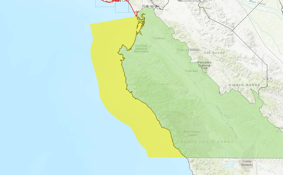
Map users can enter an address to find out whether it is within an area that could experience tsunami flooding. CGS says the maps use new data and computer modeling to show how far a surge of water might go in a worst-case scenario, but there is also a small buffer to roads or landmarks to help officials with evacuation plans.
"After 10 years of research following the Tohoku-Oki earthquake and tsunami in Japan, we're releasing maps with many improvements to keep Californians safe,” said Dr. Steve Bohlen, Acting State Geologist of California and head of CGS. “Japan utilized data from several hundred years of tsunami records in its planning, which seemed perfectly reasonable, then was hit by a once-a-millennium tsunami. So, we’re using a thousand-year scenario as the baseline for our new maps, hoping to avoid the tragic loss of life experienced there. While damaging tsunamis are infrequent in California, if you’re on the coast, you need to be aware of this potential hazard.”
According to CGS, there have been 150 tsunamis in California since 1800, but most were not noticeable. The most recent one to cause damage was the 2011 tsunami that caused more than $100 million in damage to ports and harbors around the state.
The most destructive tsunami to hit the state happened in March 1964 when the CGS said surges reaching 21 feet high hit Crescent City after a 9.2 magnitude earthquake in Alaska. The CGS believes the biggest tsunami threat for California would be from another big earthquake in the Aleutian Islands.
If a large earthquake happened there, the CGS predicts that the first surges could hit Monterey County in about five hours.
"That may seem like a lot of time, but it will take an hour or so for the National Tsunami Warning Center to issue a warning to California and then additional time for local authorities to determine whether an evacuation is necessary, " said Rick Wilson, head of the CGS Tsunami Program. "The bottom line is, if you’re near the coast and feel strong shaking from a local earthquake or get an official notification to evacuate, move inland as soon as possible.”
In Monterey County specifically, the CGS said the City of Monterey and Moss Landing saw small increases in hazard areas because of higher projected surges. High dunes near Salinas River State Beach and Monterey Dunes Colony Association were removed.
The updates also take into account tsunamis with both local and distant source tsunamis. The CGS said the San Gregorio Fault running through the canyon in Monterey Bay could have a landslide producing a surge that could hit the coast within minutes if it has a large enough earthquake.
The CGS said Moss Landing harbor was severely damaged after the 2011 tsunami. The agency reports that nearly all dock piles were damaged, and damages amounted to more than $2 million with 2020 inflation.
The agency has issued hazard area maps for seven California counties but said it hopes to update the maps for the rest of the coast within the next two years. The other two counties with updated maps are Alameda and San Mateo Counties.
See the updated Monterey County map below.

