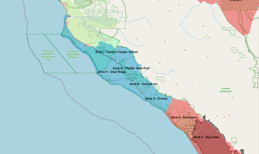
Pre-planned evacuation zones along Big Sur coast removed
BIG SUR, Calif. (KION)
UPDATE 8/25/2020 2:30 p.m. The Monterey County Sheriff's Office has removed pre-planned evacuation zones from its map to avoid confusion.
The areas along the Big Sur coast were highlighted in blue, but were not under evacuation orders or warnings. The pre-planned evacuation zones were considered a step before an evacuation warning and an indication that one may come.
Areas that are currently under evacuation orders and closed to everyone include:
- Zone A- Big Creek. This includes the east and west side of Highway 1 from and including Partington Ridge Road south to Nacimiento Ferguson Road.
- Zone B- Lucia. This includes the Esselen Institute, South Coast Center, Dolan Ridge Road, Julia Pfeiffer Burns State Park, Limekiln State Park, Kirk Creek Campground, Big Creek Preserve, Lucia and the New Camaldoli Hermitage.
- Zone C-Partington. This includes Highway 1 and tributary roads between Partington Ridge Road in the north and Nacimiento Ferguson Road in the south.
The entire forest around the fire is closed to non-residents, and residents are told to stay away from evacuated areas.
PREVIOUS STORY: A stretch of coastline along Highway 1 is in what officials are calling pre-planned evacuation zones.
The area is just north of the Dolan Fire and extends from the Little Sur River to the Partington area where evacuation orders are in effect.
The area is composed of seven pre-planned evacuation zones:
- Zone D- Grimes
- Zone E- Ventana Inn
- Zone F- Post Ranch
- Zone G- Pfeiffer State Park
- Zone H- Clear Ridge
- Zone I- Captain Cooper School
- Zone J-Andrew Molera
The area is not under an evacuation warning or order. The blue pre-planned evacuation zone is the step before an evacuation warning and an indication that a warning may come.
