Florida’s east coast is under a hurricane watch as the state grapples with Hurricane Ian’s devastation

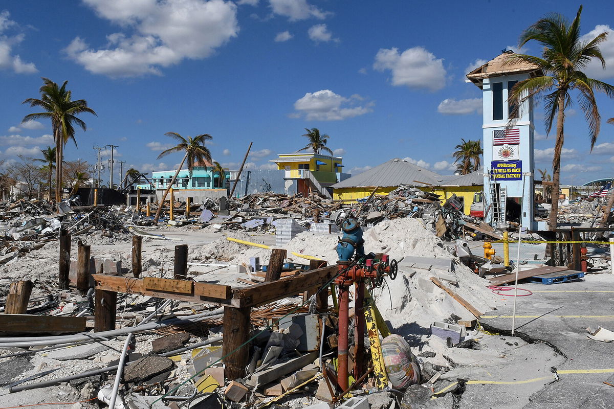
The heavily damaged area near the pier in Fort Myers Beach
By Aya Elamroussi and Holly Yan, CNN
A rare November hurricane could batter Florida’s east coast this week as residents try to recover from deadly Hurricane Ian.
Subtropical Storm Nicole is forecast to keep strengthening and is expected to be a Category 1 hurricane when it approaches Florida’s east coast late Wednesday into Thursday morning, the National Hurricane Center said Monday.
Warmer than normal ocean waters in the region will allow strengthening as the system develops and could lead to the formation of a November hurricane, CNN Meteorologist Brandon Miller said.
The last hurricane to strike the US in November was Hurricane Kate in 1985.
A hurricane watch is now in effect along the east coast of Florida, from the Volusia/Brevard county line to Hallandale Beach, the National Hurricane Center said.
The watch extends from just north of Miami to the Space Coast and includes Fort Lauderdale, West Palm Beach, Cape Canaveral and Melbourne.
A storm surge watch has also been issued for parts of Florida and Georgia, from Altamaha Sound to Hallandale Beach and from the mouth of the St. Johns River to East Palatka.
Florida officials have warned residents — including some recently hit by devastating Hurricane Ian — that the new storm could bring heavy rain and damaging winds this week.
“Heavy rainfall, coastal flooding, gale force winds and rip tides will impact eastern Florida and the southeast US,” CNN Meteorologist Robert Shackelford said.
Rainfalls in the Sunshine State could range between 2 and 4 inches, with isolated amounts possibly exceeding 6 inches, Shackelford said.
DeSantis urges residents to prepare for coastal flooding
Already, the US territories of Puerto Rico and Virgin Islands are under a flash flood watch through Monday afternoon. A hurricane warning is in effect for the northwest Bahamas as the storm is expected to be at or near hurricane strength when it passes near or over the northwest Bahamas and reaches Florida’s east coast late Wednesday, according to the National Hurricane Center.
“Regardless of Nicole’s exact intensity, the storm’s large size will likely cause significant wind, storm surge, and rainfall impacts over a large portion of the northwestern Bahamas, Florida, and the southeastern coast of the United States during the next few days,” the center said in an advisory Monday.
Areas south of Tampa — some of which are still trying to recover from Hurricane Ian’s destruction in September — could get drenched with 2 to 4 inches of rain.
Orlando could get 1 to 2 inches of rain, and areas south of Jacksonville could be hit with 1 to 4 inches.
Ahead of the storm, Florida Gov. Ron DeSantis urged residents Sunday to take precautions.
“I encourage all Floridians to be prepared and make a plan in the event a storm impacts Florida,” DeSantis said in a news release.
DeSantis said residents should prepare for an increased risk of coastal flooding, heavy winds, rain, rip currents and beach erosion.
On Tuesday, Election Day, much of the Florida Peninsula can expect breezy to gusty conditions. Chances of rain are expected to increase throughout the day for central and eastern cities such as Miami north to Daytona Beach and inland toward Orlando and Okeechobee.
“Conditions may deteriorate as early as Tuesday and persist into Thursday night/Friday morning,” the National Weather Service in Miami said.
“Impacts to South Florida may include rip currents, coastal flooding, dangerous surf/marine conditions, flooding rainfall, strong sustained winds, and waterspouts/tornadoes.”
DeSantis said officials are coordinating with local emergency management authorities across the state’s 67 counties.
The goal is to “identify potential resource gaps and to implement plans that will allow the state to respond quickly and efficiently ahead of the potential strengthening” of the storm system, the statement said.
Will the storm delay moon rocket launch?
NASA is monitoring the situation ahead of its plan to launch moon rocket Artemis next week, but is keeping the rocket out on its launch pad at the Kennedy Space Center for now, the agency said Monday.
“Teams at Kennedy will continue to monitor the weather, make sure all personnel are safe, and will evaluate the status of the Monday, Nov. 14, launch attempt for the Artemis I mission as we proceed and receive updated predictions about the weather,” NASA said in a statement.
This is the second time in six weeks that a powerful storm has threatened the first test flight of the most powerful rocket ever built. At the end of September, Hurricane Ian forced NASA to roll the rocket back to the safety of its garage, known as the Vertical Assembly Building, after two failed launch attempts due to a hydrogen leak and other technical issues.
Hurricane Ian made landfall September 28 as a strong Category 4 storm on the west coast of the Florida peninsula, packing winds of nearly 150 mph.
The ferocious storm killed at least 120 people in Florida, destroyed many homes and leveled small communities. Thousands of people were without power or water for running days.
The-CNN-Wire
™ & © 2022 Cable News Network, Inc., a Warner Bros. Discovery Company. All rights reserved.
CNN’s Brandon Miller, Hannah Sarisohn and Kristin Fisher contributed to this report.