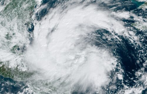
Potential Tropical Cyclone Six forms in Gulf with tropical storm watch issued for Mexico
By Gene Norman, Elisa Raffa, Allison Chinchar and Mary Gilbert, CNN Meteorologists and Ashley R. Williams, CNN
(CNN) — Potential Tropical Cyclone Six has formed over the warm waters of the southern Gulf of Mexico with over two months left of 2024’s Atlantic hurricane season, the National Hurricane Center said Sunday.
The storm that formed in the Gulf’s Bay of Campeche was located about 320 miles south of Brownsville, Texas late Sunday with maximum sustained winds of 50 mph, according to the hurricane center’s 11 p.m.ET update.
“The system is moving toward the northwest near 5 mph and a slow northwestward motion followed by a turn more northward is expected over the next day or two,” the hurricane center said.
“On the forecast track, the disturbance is expected to move just offshore ofthe northern Gulf Coast of Mexico throughTuesday, and approach the Upper Texas and Louisiana coastline on Wednesday,” forecasters added.
Mexico’s government issued a tropical storm watch from Barra del Tordo northward to the mouth of the Rio Grande ahead of potential impacts.
The National Weather Service in the United States added a Tropical Storm watch from the mouth of the Rio Grande to Port Mansfiled, about 60 miles up the coast.
The hurricane center said watches could also be issued for more areas of southern Texas and Louisiana Monday.
The system is expected to become a tropical storm on Monday with more significant intensification expected on Tuesday as a result of very warm Gulf waters. It is forecast to strengthen to hurricane status before it reaches the Texas-Louisiana Gulf Coast, according to the hurricane center.
The next named storm will be called Francine.
An elongated area of low pressure over the southwestern Gulf of Mexico continued producing a large area of showers and thunderstorms on Sunday, the hurricane center said.
The storm’s title, Potential Tropical Cyclone Six, is a designation used by the hurricane center to denote a storm that has not yet formed but is expected to soon and will bring impacts within the 48-hour window requiring alerts to be issued.
The storm comes during an already unusually active Atlantic hurricane season which has so far produced five named storms by mid-August – three of which became hurricanes. It also comes days before the statistical peak of the Atlantic hurricane season on September 10.
Data from Colorado State University researchers show about 68% of all Atlantic tropical activity typically occurs after September 1. The latest activity in the Gulf follows a rare quiet period in the Atlantic, with no named storms forming since Ernesto in mid-August.
The warm waters of the southern Gulf, where temperatures are in the low 90s Fahrenheit and around 5 degrees above average, contributed to the storm’s early strengthening over the weekend.
An Air Force Reserve hurricane hunter plane investigated the system Sunday afternoon, still unorganized and not yet reaping the benefits of those warm water fuels.
Weak steering conditions in the upper atmosphere could cause erratic movements and it’s too early to determine the system’s potential strength or where it may make landfall.
However, “interests along the Gulf coast of Mexico, upper Texas, and Louisiana coasts should closely monitor the progress of this system,” the hurricane center said.
Portions of the northwestern Gulf Coast could potentially see strong winds, dangerous storm surge and flooding from heavy rainfall starting as early as Tuesday.
Tropical downpours are expected to bring 4 to 8 inches of rain, with up to 12 inches possible from the coast of far northeast Mexico northward along portions of the Texas coast and into Louisiana through Thursday. This rainfall would lead to the risk of flash and urban flooding.
Storm surge and rough surf could cause minor coastal flooding along the Mexican coastline. Tropical storm conditions are possible within the watch area along the northern coast of Mexico beginning Tuesday.
The storm could affect many of the same areas of Texas hit hard in July by Hurricane Beryl, which made landfall southwest of Houston as a Category 1 and brought extensive flooding and wind damage, causing significant power losses in and around Houston.
For reference, the last season to have two named storms make landfall in Texas was 2020, when Category 1 Hurricane Hanna struck near Brownsville and Tropical Storm Beta struck Port Lavaca.
If the storm hits the Texas coastline as a hurricane, it would be the first double punch in 16 years. The last time two hurricanes struck Texas in the same year was 2008 with Dolly in Corpus Christi and Ike in Galveston and Houston.
The last named storm to directly hit Louisiana was Category 4 Hurricane Ida in 2021.
Forecasters monitor 2 other systems in Atlantic
The National Hurricane Center is also monitoring two other systems in the eastern Atlantic.
Showers and thunderstorms associated with an elongated area of low pressure over the central tropical Atlantic continue to show some signs of organization.
Environmental conditions appear favorable for this system to develop further. “A tropical depression could form while the system meanders over the central tropical Atlantic through Monday and then begins to move generally westward through the rest of the week,” the hurricane center said, putting chances of formation over the next seven days at 70%.
Further east, low pressure several hundred miles southwest of the Cabo Verde Islands is producing a broad area of disorganized showers and thunderstorms.
This system is expected to move very little during the next couple of days until it potentially interacts with a tropical wave forecast to move off the west coast of Africa on Monday.
A tropical depression could form by the middle or latter part of the week while the system begins moving slowly northwestward. The hurricane center said this system has a 50% chance of forming.
The-CNN-Wire
™ & © 2024 Cable News Network, Inc., a Warner Bros. Discovery Company. All rights reserved.

