Secondary System Blasts Through Overnight
A secondary system will bring the threat of brief heavy rain, thunderstorms, and gusty winds early Tuesday morning then move out late. Then, a weak system will drift by Wednesday and may produce a few showers. We’ll have a dry day on Thursday before rain chances return Friday/Saturday.
AIR QUALITY: Good
**FLOOD WARNING***
… for the Salinas River from around Soledad to Monterey Bay from Tuesday morning until further notice...
*Minor flooding is forecast. However, a higher secondary crest is expected to occur Wednesday. Stay tuned for further updates.
*At 19.0 feet, Lowland agricultural areas will have minor flooding.
At 23.0 feet, A few homes near the Salinas River along the reach of the river gage will begin to flood. River Road near Spreckels will have minor flooding.
At 24.0 feet, The lowest areas of agricultural land along the lower portions of the Salinas River will have significant flooding. River Road will have moderate flooding. Spreckels Boulevard will begin to flood.
- At 9:00 PM PST Monday the stage was 14.5 feet.
- Forecast...The river is expected to rise above flood stage (23 ft) Tuesday morning and continue rising to 24.3 feet late Tuesday morning. Additional rises are possible thereafter.
- Flood stage is 23.0 feet.
- Flood History...This crest compares to a previous crest of
23.4 feet on 03/03/1983.
***FLOOD WARNING***
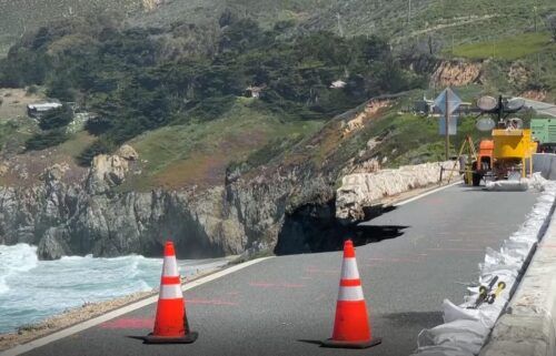
… for the Big Sur River extended until 10:30AM Tuesday.
*Small stream flooding caused by excessive rainfall continues.
*Flooding of rivers, creeks, streams, and other low-lying and flood-prone locations is imminent or occurring. Streams continue to rise due to excess runoff from earlier rainfall. Low-water crossings are inundated with water and may not be passable.
- At 1023 PM PST, Flooding is already occurring in the warned area. Additional updates are expected by 10:15 am.
- Flooding is occurring along the Big Sur River near Big Sur.
- Some locations that will experience flooding include... Big Sur Village and Andrew Molera State Park.
Turn around, don't drown when encountering flooded roads. Most flood deaths occur in vehicles.
Stay away or be swept away. River banks and culverts can become unstable and unsafe.
Flooding is occurring or is imminent. It is important to know where you are relative to streams, rivers, or creeks which can become killers in heavy rains. Campers and hikers should avoid streams or creeks.
Please report observed flooding to local emergency services or law enforcement and request they pass this information to the National Weather Service when you can do so safely.
*FLOOD WATCH*
…for the entire Central Coast and KION viewing area, now through Tuesday afternoon.
* Flooding caused by excessive rainfall is possible.
* Excessive runoff may result in flooding of rivers, creeks, streams, and other low-lying and flood-prone locations. Creeks and streams may rise out of their banks. Flooding may occur in poor drainage and urban areas. Low-water crossings may be flooded. Storm drains and ditches may become clogged with debris. Extensive street flooding and flooding of creeks and rivers are
possible.
*You should monitor later forecasts and be alert for possible Flood Warnings. Those living in areas prone to flooding should be prepared to take action should flooding develop.
Overnight: Patchy dense fog in low areas. Increasing clouds and southerly winds with rounds of heavy showers and thunderstorms moving through. Winds will be strongest in the middle of the night, then decrease a bit and remain gusty. Lows in the 40s-50s.
***GALE WARNING***
… in effect for the near coastal waters from Pigeon Point south to Point Piedras Blancas from 9PM Monday until 9AM Tuesday
… and for Monterey Bay from 3AM Tuesday until 9AM Tuesday
*South winds 30 to 35 kt with gusts up to 50 kt and seas 8 to 17 ft expected.
*Strong winds will cause hazardous seas which could capsize or damage vessels and reduce visibility.
Mariners should alter plans to avoid these hazardous conditions. Remain in port, seek safe harbor, alter course, and/or secure the vessel for severe conditions.
**WIND ADVISORY**
…for the entire KION viewing area in effect from 10pm Monday evening until 4pm Tuesday afternoon.
*Southwest winds 15 to 30 mph with gusts up to 45 mph expected. For higher elevations, south winds 25 to 35 mph with gusts up to 60 mph expected.
*Gusty winds could blow around unsecured objects. Tree limbs could be blown down and a few power outages may result.
*Including areas: Southern Salinas Valley, Arroyo Seco, and Lake San Antonio, Santa Lucia Mountains and Los Padres National Forest, Mountains of San Benito and Interior Monterey County including Pinnacles National Park, Northern Salinas Valley, Hollister Valley, and Carmel Valley and Southern Monterey Bay and Big Sur Coast.
*Santa Cruz Mountains-Santa Clara Valley, Eastern Santa Clara Hills,-East Bay Hills-Northern Monterey Bay.
* Gusty winds could blow around unsecured objects. Tree limbs could be blown down and a few power outages may result.
*Use extra caution when driving, especially if operating a high profile vehicle. Secure outdoor objects.
Tuesday: Partly cloudy with rounds of showers & thunderstorms. Brief heavy rain possible. Cool and gusty with highs in the 50s.
***HIGH SURF WARNING***
… for the immediate coast of Santa Cruz & Monterey Counties in effect from 8AM Tuesday until 2AM Wednesday.
*Dangerously large breaking waves of 20 to 25 feet.
* IMPACTS...Breaking waves can sweep people off jetties and docks, and into dangerous seas. Life-threatening swimming conditions and significant beach erosion can be expected.
A High Surf Warning indicates that dangerous, battering waves are expected to pound the shoreline, bringing potentially damaging and life-threatening conditions. It is advised that people remain away from the shoreline during this event, especially staying off rocks, jetties and beaches.
Extended: Dry conditions return Wednesday/Thursday before the next system approaches late in the week.
-------------------------------------------------------------------------
This week's normal temperatures:
--COASTAL CITIES--
LOW: 43ºF
HIGH: 61ºF
--INLAND CITIES--
LOW: 38ºF
HIGH: 61ºF
----------------------------------------------------------------------------
-The outlook from the Climate Prediction Center for January 17th – 23rd calls for the likelihood of BELOW normal temperatures and ABOVE normal precipitation.
- El Niño/La Niña STATUS: La Niña Advisory
- Forecast: Weak La Niña continues through winter, becomes neutral by Spring
-Area drought status: Extreme drought (D3) for southern San Benito and southeastern Monterey Counties, Severe drought (D2) for the Salinas Valley to the bay and northern San Benito County, Moderate drought (D1) for Santa Cruz County and the coast and coastal mountains of Monterey County