Floods And Damaging Winds
Life-threatening weather on the way!
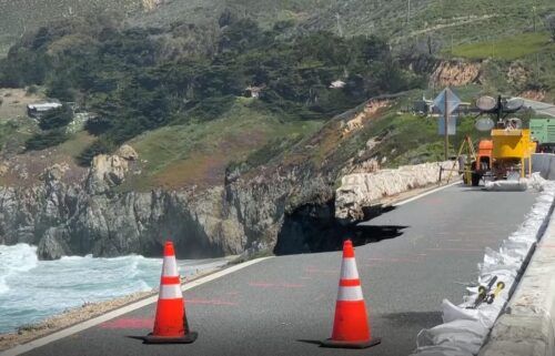
A potent storm system packed with a deep stream of moisture will begin impacting our area Wednesday morning. Expect constant moderate rain in the coastal mountains Wednesday enhanced by a frontal system late Wednesday into Thursday. Flooding looks likely on creeks and streams in Santa Cruz County and on the Big Sur Coast. It will be possible in many other low areas. If that weren’t enough, a long period wind event will also begin on Wednesday morning and could last all the way until Thursday morning. Sustained winds of 30-50mph likely for the exposed coast and ridges, with gusts over 60mph possible. Due to recent rains causing saturated soils and drought-stressed trees, it is even more likely that we will see trees down with blocked roads, power outages, and property damage. More rain is then possible this weekend with weaker systems moving through, the storm door will remain open through next week.
AIR QUALITY: Good
*FLOOD WATCH*
… for the entire KION coverage area from late Tuesday night through Thursday.
A potent Pineapple Express will move into the region Wednesday and continue into Thursday. This will bring substantial rainfall to the Bay Area and Monterey Bay region on top of already saturated soils. As a result look for rapid rises in area creeks, streams, and rivers. Bankfull exceedance is possible. In addition strong gusty winds will bring branches and trees down, which may cause localized damming of water ways. Rain will taper by Thursday afternoon, allowing for rivers to level off and begin to lower.
*Flooding caused by excessive rainfall is possible.
*Excessive runoff may result in flooding of rivers, creeks, streams, and other low-lying and flood-prone locations. Creeks and streams may rise out of their banks. Flooding may occur
in poor drainage and urban areas. Low-water crossings may be flooded. Storm drains and ditches may become clogged with debris. Extensive street flooding and flooding of creeks and rivers are
possible.
You should monitor later forecasts and be alert for possible Flood Warnings. Those living in areas prone to flooding should be prepared to take action should flooding develop.
Overnight: Increasing clouds, with light widespread rain starting around midnight. Mostly cloudy overnight, with lows in the upper 40s to low 50s. South to southeast winds will become stronger with gusts near 20mph, and rain becoming moderate at times heading into sunrise.
***GALE WARNING***
… in effect from 3AM Wednesday until 9AM Thrusday for the near coastal waters from Pigeon Point south to Point Piedras Blancas including Monterey Bay
*Southeast winds 20 to 35 kt with gusts up to 45 kt and seas 9 to 14 ft expected.
*Strong winds will cause hazardous seas which could capsize or damage vessels and reduce visibility.
Mariners should alter plans to avoid these hazardous conditions. Remain in port, seek safe harbor, alter course, and/or secure the vessel for severe conditions.
***HIGH WIND WARNING***
… for the entire KION Coverage Area in effect from 4AM Wednesday until 10AM Thursday
*Southerly winds 20 to 30 mph with gusts up to 50 mph in valley locations. 30 to 40 mph with gusts up to 60 mph above 1000 feet. Local gusts to around 70 mph coast and highest peaks.
*Damaging winds will blow down trees and power lines. Widespread power outages are expected. Travel will be difficult, especially for high profile vehicles.
*Saturated soils will allow for trees to topple more easily during this prolonged wind event. The
strongest winds will be during the cold frontal passage late Wednesday afternoon through early Thursday morning.
People should avoid being outside in forested areas and around trees and branches. If possible, remain in the lower levels of your home during the windstorm, and avoid windows. Use caution if you must drive.
Wednesday: Widespread light to moderate rain early, then becoming mostly cloudy with rain on and off in the coastal mountains—dry but windy elsewhere. A cold front will then bring a period of heavy rain to the region and damaging, gusty winds into the evening. Heavy rain is likely to cause flooding of streams and low areas. Damaging winds are likely to cause power outages and potentially property damage. Wind & rain taper off late. Highs in the 50s to low 60s.
Thursday: Mostly cloudy with rounds of showers and thunderstorms. Storms could have heavy rain which could cause more isolated flooding impacts. Winds will remain gusty but won’t be as extreme as Wednesday evening. Highs in the 50s to around 60ºF.
***HIGH SURF WARNING***
… for the immediate coast of Monterey County in effect from 7am Thursday until 3AM Friday.
*Dangerously large breaking waves of 20 to 27 feet expected.
*Extremely dangerous swimming and surfing conditions and localized beach erosion. Very arge shorebreak. Much farther than normal wave runup. Some beaches will be inundated at high tide. Rounding or climbing over rock outcroppings will be extremely dangerous. Fishing off rock walls or jetties may wash you out to sea.
*The ocean is an unrelenting environment with little to no chance of rescue. Respect this force of nature and remain well away from hazardous ocean conditions.
Everyone should remain out of the water due to life-threatening surf conditions. Stay off of jetties, piers, and other waterside infrastructure.
**HIGH SURF ADVISORY**
… for the immediate coast of the north side of Monterey Bay in effect from 7AM Thursday until 3AM Friday.
*Large breaking waves of 17 to 22 feet.
*Dangerous swimming and surfing conditions and localized beach erosion. Large shorebreak. Farther than normal wave runup. Some beaches will be inundated at high tide. Rounding or climbing over rock outcroppings will be extremely dangerous. Fishing off rock walls or jetties may wash you out to sea.
*The ocean is an unrelenting environment with little to no chance of rescue. Respect this force of nature and remain well away from hazardous ocean conditions.
Remain out of the water to avoid hazardous swimming conditions.
Extended: We’ll get a bit of a break on Friday, although a few isolated showers will be possible. The next system will arrive late Saturday into Sunday with moderate rains and gusty winds. Another storm is likely early next week.
-------------------------------------------------------------------------
This week's normal temperatures:
--COASTAL CITIES--
LOW: 42ºF
HIGH: 61ºF
--INLAND CITIES--
LOW: 37ºF
HIGH: 61ºF
----------------------------------------------------------------------------
-The outlook from the Climate Prediction Center for January 11th – 17th calls for the likelihood of ABOVE normal temperatures and ABOVE normal precipitation.
- El Niño/La Niña STATUS: La Niña Advisory
- Forecast: Weak La Niña continues through winter, becomes neutral by Spring
-Area drought status: “Severe Drought” for most of the viewing area with “Extreme Drought” in southern San Benito and southeastern Monterey Counties. The southeastern third of San Benito County has been upgraded to “Exceptional Drought”