Offshore flow will continue for the next few days
Offshore flow will continue for the next few days, with warm, dry weather expected. Fire danger will remain elevated, but after another round of weaker winds Monday night, winds should die down for the most part. Flow will switch back on flow mid-week with some low clouds/fog possible at the coast and cooling through the end of the week. Halloween weekend is currently looking rather pleasant.
***RED FLAG WARNING***
From the National Weather Service in Monterey…
… for the Northern Diablo Range extended until 5PM Tuesday
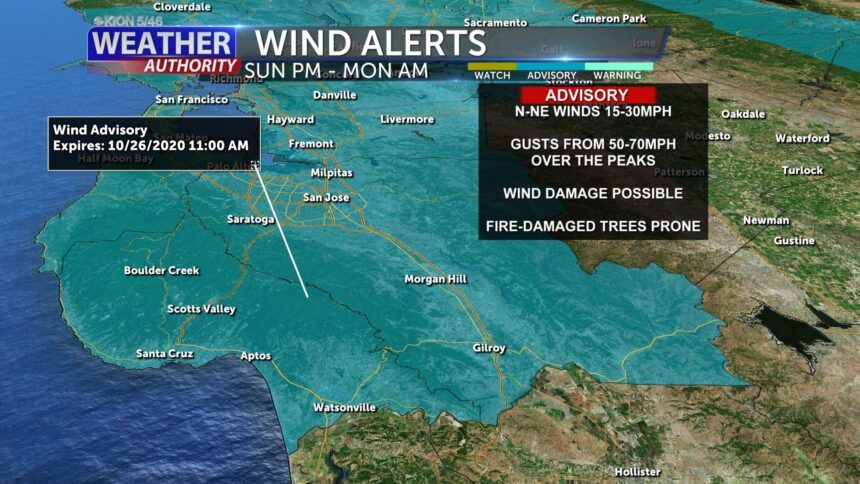
… for Santa Cruz County and the Santa Clara Valley from 8PM Sunday until 11AM Monday
WIND: North to northeast winds 15-30mph with gusts possible between 50-70mph over the highest elevations. Winds will increase late Sunday afternoon, peaking Sunday night into Monday morning. Breezy offshore winds will continue until Tuesday for the hills.
HUMIDITY: 5-15% with little recovery at night.
Any fires that develop will likely spread rapidly. A Red Flag Warning means that critical fire weather conditions are either occurring now or will shortly. A combination of strong winds, low relative humidity, and warm temperatures can contribute to extreme fire behavior.
**Wind Advisory**
From the National Weather Service in Monterey…
… for Santa Cruz & Santa Clara Counties through 11AM Monday.
Northeast winds 20 to 35 mph with gusts up to 55 mph below 1000 feet. Gusts to 70 mph above 1000 feet.ADVERTISING
Damaging winds could blow down trees and power lines. Widespread power outages are possible. Travel could be difficult, especially for high profile vehicles.
In addition to fire weather concerns these winds will have the potential to bring down fire weakened trees and branches across the region. Any temporary structures such as tents and scaffolding will be compromised.
This event has the the potential to be as strong or stronger as winds during the 2017 Wine Country Fires with widespread potential for damaging winds throughout the Bay Area Sunday night.
Monitor the latest forecasts and warnings for updates on this situation. Fasten loose objects or shelter objects in a safe location prior to the onset of winds.
Overnight: Clear and dry with gusty winds over the hills, especially in the north. Wind gusts may occasionally mix down into the lower elevations. Lows will remain in the 50s where windy (like in the hills), but drop into the 40s for lower elevations and calmer areas.
Monday: Sunny and potentially smoky. Offshore flow will push highs into the 70s for most areas. Winds will weaken during the day and then pick up in the hills once again overnight, though not as strong as the previous night.
Tuesday: Sunny with some fog possible along the coast after dark. Warm, with highs in the 70s to around 80ºF.
Extended: The warmest day of the week will likely be Wednesday, then temperatures will cool into the end of the week as flow switches back onshore. Highs will remain at or above seasonal normal. Lows will be at or slightly below, so after an extended period of time with above-normal low temperatures, the nights will be rather chilly. Some higher elevation valleys in San Benito County may see a touch of frost. Highs will warm up a bit next weekend after a weak weather system passes by to our north.
-------------------------------------------------------------------------


