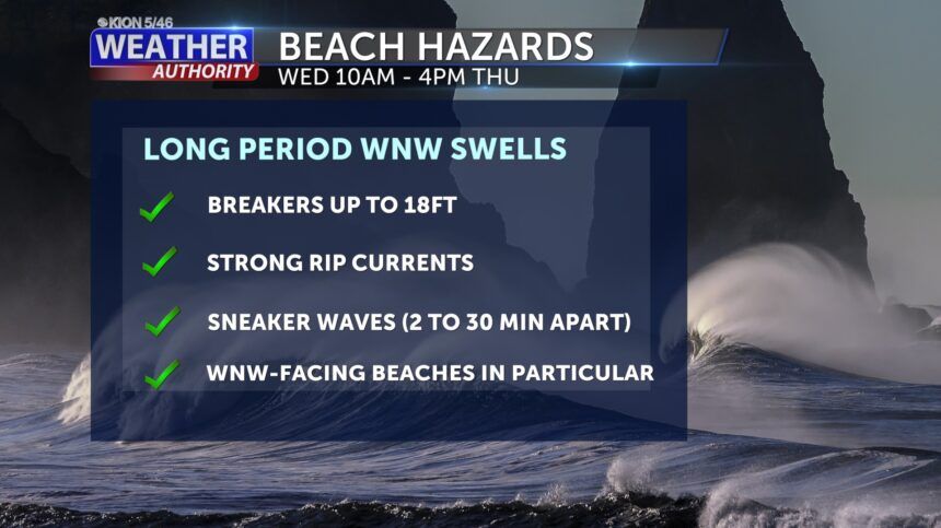
Sneaker wave beach advisory through Thursday afternoon
Air Quality Report (As of 8:20am)
Good to moderate for all reporting areas.
Weather Story:
High pressure will continue to dominate the weather over the West for the next week. Weak weather systems will slide by to our north or approach from the west and fall apart, but no major impacts are expected. The next weather system will approach from the west by Thursday which will bring a few clouds back, but that’s about it. The ridge will strengthen through the weekend with light offshore flow. This will keep lows chilly, but afternoon highs will likely be warm. No rain is in the forecast for the next week, but there are some hints that starting mid-week next week, the pattern may finally change. Those changes are still low in confidence, however.
From the National Weather Service in Monterey:
*Beach Hazards Statement*
… for the immediate coast of Monterey County and the immediate “North Coast” of Santa Cruz County from 10 AM Wednesday morning through 4 PM Thursday evening.
Very Long Period Swell will bring Dangerous Sneaker Waves...
A very long period WNW swell will impact the Sonoma to Big Sur coast through the day on Wednesday and persist into Thursday. Initial forerunner waves of 24 to 27 seconds will begin to arrive along the Sonoma coast overnight Tuesday night into early Wednesday morning before spreading southward through the day. The primary timeframe of concern from this event will be midday Wednesday into Thursday morning as the wave heights rise to 3 to 7 feet at a periodicity of 19 to 24 seconds. A high to extreme risk of sneaker waves will exist during this timeframe. The largest energetic sneaker waves will arrive irregularly every few minutes to as infrequently as once every 30 minutes during otherwise deceptively calmer seas and consequently may catch those on coastal jetties, rocks, piers, or shorelines off guard and may injure them or knock them into the cold, turbulent ocean. Beachcombing is not advised during this timeframe. In addition, strong rip currents will accompany the energetic wave train, particularly at WNW facing beaches. These type of events claim lives each year along our coast so extreme vigilance is advised if visiting the coast. Finally, moderate to locally large breaking waves of 14 to 18 feet will be possible later in the day on Thursday at WNW facing beaches as the swell period decreases and swell heights increase, thus this product will be in effect through the day Thursday.
A very long period WNW swell with initial periods in excess of 20 seconds will bring a threat of dangerous sneaker waves to area beaches. Enhanced strength of rip currents and moderate to large breaking waves at the end of the event.
The main impacts will be felt at W-WNW beaches.
Potential sneaker waves will create dangerous conditions at area beaches. Steep beaches will have a higher risk of sneaker wave activity with greater wave run-up onto beaches. Occasionally larger waves will also wash over jetties and rock outcroppings that normally stay dry.
A Beach Hazard Statement for sneaker waves means that conditions are present to support an increased danger of unsuspecting beach goers being swept into the sea by a wave. People walking along the beach should never turn their back to the sea. Fisherman should
avoid fishing from rocks or jetties. Beachcombing is not advised.
Wednesday: A few low clouds near the coast and a few high clouds passing through, otherwise sunny. Expect coastal highs in the upper 50s to mid 60s with mainly 60s to low 70s inland.
Extended: A weather system will approach on Thursday with increased clouds but no rain and not much of a temperature change. The weather will remain tranquil through the weekend with chilly mornings and warm afternoons along with dry conditions and mostly sunny skies. The pattern may begin to change by mid-week next week. Stay tuned.


