Areas hit hard in recent weeks from tornadoes could face severe weather again this weekend
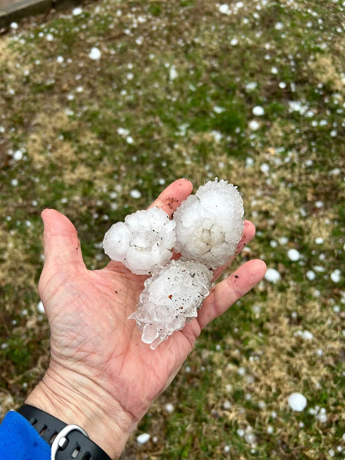
Large hail fell in Davenport
By Allison Chinchar, CNN Meteorologist
More than 50 million people are under the threat of severe storms Saturday from the Gulf Coast to the Great Lakes. Some of these same areas are still cleaning up from severe storms over the previous few weeks.
“Severe thunderstorms capable of large to very large hail and damaging gusts are possible from the lower to mid Mississippi Valley westward into parts of the Ozarks, Ark-La-Tex and Sabine River Valley,” the Storm Prediction Center said.
A level 3 out of 5 “enhanced” risk for storms has been issued across parts of Missouri, Louisiana and Arkansas, including Little Rock, Arkansas, and St Louis. There’s a level 2 of 5 “slight” risk for locations surrounding that enhanced risk zone, including Memphis, Tennessee; Shreveport, Louisiana; and Jackson, Mississippi.
“Models are trending a little slower with the evolution of this storm system increasing the possibility of strong to possibly severe storms in advance of the associated cold front,” the National Weather Service office in Little Rock said.
The Little Rock weather service also emphasized that while the tornado threat is low, it cannot be discounted entirely, especially if any super cells develop.
Arkansas and Mississippi were each hit by an EF-4 tornado just weeks ago. Many still have tarps covering their roofs, and have yet to finish clearing up debris and damage to businesses. Now, new storms are set to arrive in many of these hard-hit areas this weekend.
Hail the size of tennis balls
Hailstones larger than golf balls, and possibly even the size of tennis balls may fall in this region Saturday afternoon and evening. The large hail threat will be focused across portions of Arkansas, Missouri, Louisiana and east Texas.
While not as deadly as tornadoes, hail can still cause significant damage to vehicles, homes, crops and livestock. Even small hailstones can have an impact when there’s enough volume.
“When hail builds up, it can cause a loss of power, bring down trees and cause flash floods and mudslides in steep areas,” the International Federation of the Red Cross states on its disasters and preparation website.
In 2022, there were over 4,400 major hailstorms reported in NOAA’s severe storms database. According to the Insurance Information Institute, hail-related insured losses between averaged between $8 billion to $14 billion a year in the last two decades.
Texas was the state with the most hail claims paid for auto and home insurance followed by Illinois, Minnesota, and Missouri — three of the states that are expected to see potential hail storms this weekend.
These storms are associated with a low pressure system that will track eastward, from the central Plains, slowly toward the Mid-Mississippi River Valley and Great Lakes by Sunday.
These strong thunderstorms are forecast to develop quickly ahead of the cold front during the early to mid-afternoon. They are expected to move out of Arkansas and Missouri by midnight and continue to race eastward through the overnight hours.
Flash flooding is also possible across this region on Saturday, as 1 to 3 inches of rain is forecast on top of already saturated soils.
“Some of this region has had recent rains, and are 150 to 600 percent of normal,” the Weather Prediction Center said. “These sensitive soils could quickly become over saturated and lead to isolated/scattered areas of flooding.”
Threat pushes east Sunday
This system will push eastward on Sunday bringing rain to the Ohio Valley and the potential for severe storms across the Southeast.
“Isolated severe thunderstorms, associated with wind-damage and hail, will be possible on Sunday in parts of the Southeast,” the Storm Prediction Center said. “Marginally severe storms will be possible further north into parts of the Ohio Valley and southern Great Lakes.”
Another concern: more rainfall across South Florida, which is cleaning up from record flooding Wednesday.
“Some of the area is still susceptible/vulnerable due to recent rainfall so this additional threat of heavy rainfall may lead to flash flooding over the urbanized corridor of southeast Florida,” the Weather Prediction Center said Saturday morning.
Rain showers are expected for Miami and Fort Lauderdale from Sunday night through Monday.
The-CNN-Wire
™ & © 2023 Cable News Network, Inc., a Warner Bros. Discovery Company. All rights reserved.