Typhoon In-fa impacting parts of Japan with its eye set on China by next week
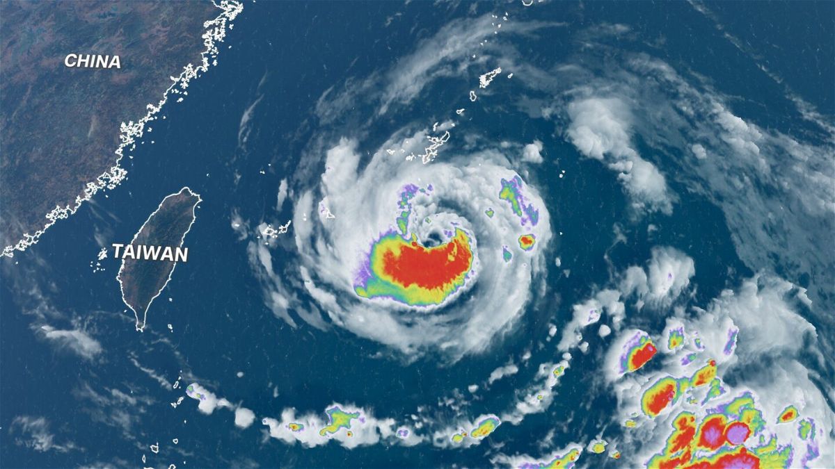
A satellite view shows Typhoon In-fa over the northwest Pacific Ocean on July 20.
By Jackson Dill and Shawn Deng, CNN
Typhoon In-fa weakened slightly Thursday morning local time over the northwestern Pacific Ocean as it impacted parts of Japan. The storm is expected to restrengthen and potentially lash Taiwan and parts of China by this weekend.
This comes after Typhoon Cempaka rapidly strengthened on approach to China’s southeastern coastline Tuesday, making landfall about 150 miles (240 kilometers) southwest of Hong Kong.
Cempaka is now over land, bringing a widespread 4 to 8 inches of rainfall to parts of Guangdong, Guangxi and Hainan provinces. Isolated locations could approach 20 inches through Friday.
In-fa a threat to Japan, Taiwan and China
Typhoon In-fa is slowly gaining strength as it swirls westward over the Pacific Ocean.
Maximum sustained winds are at 103 mph (165 kph), as of the 5 p.m. ET Wednesday (5 a.m. Hong Kong time) update from the Joint Typhoon Warning Center.
The storm is about 190 miles (305 kilometers) away from Kadena Air Base in Okinawa and is bringing rain and tropical storm conditions to parts of Japan’s southern island.
These rain chances will remain elevated through the duration of this week as In-fa slowly tracks west.
The slow-moving nature of this storm will cause rainfall totals to increase substantially. Many of the southern Japan islands will see totals of at least 10 inches, with totals of more than 20 inches likely in higher elevations.
“In-Fa will pass south of Okinawa, closer to Miyakojima, which is built to handle the accompanying rains and wind. The problem may arise as the system moves near Taipei,” said CNN meteorologist Tom Sater.
Maximum winds near the center of In-fa are forecast to approach 109 mph (175 kph) in the southern Japan islands by Thursday, when the storm may reach peak intensity.
“The mountain chain in Taiwan could squeeze up to a meter’s worth of rain over the region, while Taiwan has been dealing with its worst drought in some 50 years. This amount of rain could lead to catastrophic flash flooding and landslides,” says Sater.
The forecast track over the next two to five days have become more certain. After tracking west through Thursday morning (Friday morning Hong Kong time), In-fa is expected to take a turn to the northwest.
This turn to the northwest should take place Friday morning (Saturday morning Hong Kong time) and will do so offshore, thus avoiding major impacts to Taiwan.
Regardless, gusty winds and flash flooding from heavy rain will be a big concern, with totals more than 12 inches in the lower elevations and more than 20 inches in the mountains of Taiwan later in the week.
In-fa is expected to continue tracking northwest after passing Taiwan to the north, possibly reaching eastern China this weekend. The current track indicates a potential landfall near Wenzhou and Taizhou, which are located on China’s coast.
“There exists potential for Typhoon In-fa to slow down and remain offshore of China while turning northward after 72 hours,” says the JTWC.
The current forecast indicates it will still be at typhoon intensity with sustained winds near the center of the storm up to 100 mph (160 kph) this weekend. Heavy rain will remain a threat from this storm through its duration.
Record rainfall in eastern China ahead of In-fa
Heavy rain in the Chinese city of Zhengzhou has broken a record, according to the city’s meteorological bureau Tuesday.
At least one person was reported dead and two missing amid the floods in China’s Gongyi city, in Henan province, according to state news outlet CGTN on Tuesday.
“The hourly precipitation and single-day precipitation this time have broken through the historical record of 60 years since the establishment of Zhengzhou Meteorological Bureau in 1951,” the Zhengzhou Meteorological Department said in a video it posted explaining the rainfall.
“The precipitation the city had in the last three days was already tantamount to the total amount of the precipitation the city had last year,” the department said.
The average annual rainfall in Zhengzhou is over 25 inches, according to the bureau. Meanwhile, according to their analysis of the recent rainfall, from 4 p.m. to 5 p.m. Tuesday the city saw 7.9 inches. From 8 p.m. Monday to 8 p.m. Tuesday, the city saw 21.8 inches of rain; and from 8 p.m. Saturday to 8 p.m. Tuesday, the city saw 24.3 inches.
The moisture associated with this rain can be connected to both Typhoons Cempaka and In-fa, despite being hundreds of miles from this part of China.
Torrential rains have hit central China’s Henan province since Friday, affecting more than 144,660 residents, according to China’s state news agency Xinhua on Tuesday. More than 10,000 have been relocated to safer places.
The highest level of rainfall was seen in Lushan County’s Pingdingshan City with 15.8 inches of precipitation, Xinhua reports, adding that rainwater has damaged more than 35 square miles of crops, causing losses worth $11.3 million.
The-CNN-Wire
™ & © 2021 Cable News Network, Inc., a WarnerMedia Company. All rights reserved.
CNN’s Hira Humayun contributed to this report.